Monday, August 31, 2009

UBS Price and Earnings Report 2009

The renowned global financial services firm UBS has just released their "Price and Earnings 2009 - A comparison of purchasing power around the globe" report, covering their studies on living cost (including prices for 122 type of goods & services), as well as wages, working hours & taxes for 14 professions in 73 cities worldwide. Since 1971, UBS conducts this survey covering more than 30,000 individual data points at the interval of every 3 years.

The result reviews that:
  • Oslo, Zurich, Copenhagen, Geneva, Tokyo and New York are the world's most expensive cities based on a standardized basket of 122 goods and services, while Kuala Lumpur, Manila, Delhi and Mumbai cost the least.
  • When rent prices are factored into the equation, New York, Oslo, Geneva and Tokyo emerge as especially pricey places to live.
  • Employees in Zurich and Geneva have the highest net wages in the world. By contrast, the average employee in Delhi, Manila, Jakarta and Mumbai earns less than 6.66% or 1/15 of Swiss hourly wages after taxes.
  • An average wage-earner in Zurich and New York can buy an Apple iPod nano with 8GB storage after 9 hours (or 1 working day) of work. At the other end of the spectrum, workers in Mumbai, need to work 20 working days – roughly the equivalent of one month's salary – to purchase the same.
  • People work an average of 1,902 hours per year in the surveyed cities but they work much longer in Asian and Middle Eastern cities, averaging 2,119 and 2,063 hours per year respectively.
  • People in Cairo and Seoul work the longest – roughly 600 hours more per year than their peers in Western Europe. People in Lyon and Paris, by contrast, spend the least amount of time at work.
  • Japan and Switzerland has the highest food price.
  • Nowhere in the world is clothing cheaper than in Kuala Lumpur and Manila.
  • Hotels most expensive in Tokyo and Paris.
  • The costliest places for city break are Tokyo, London and Doha while the cheapest are Mexico City, Kuala Lumpur and Jakarta.
  • Crisis-driven currency fluctuations cause shifts in the rankings from last survey (year 2006).

Beside the Apple iPod nano, price of McDonald's Big Mac, 1kg bread and 1kg rice are also benchmarked for the purchasing power in the cities (refer to Page 11 of the report).

Wages and working hours are benchmarked among the following professions:

  • Car mechanic
  • Building labourer
  • Skilled industrial worker
  • Factory worker
  • Engineer
  • Department head
  • Product manager
  • Primary school teacher
  • Bus driver
  • Cook
  • Personal assistant
  • Sales assistant
  • Call center agent
  • Bank credit officer

Click here to download the full UBS Price and Earnings Report 2009.

You might also be interested to read about:

Mercer Worldwide Cost of Living Survey 2009

Using GMapTool to combine multiple maps into one mapset file for Garmin GPS

We mentioned earlier that Garmin GPS navigator supports several mapset files. That should be enough for normal users.

Saving different map into different mapset file also makes it easy to replace the map to newer version in the future, as well as convenient to remove a single map from the GPS storage.

However, if you have a lot of map that you want to load into your GPS, or you want to store all the maps into SD card which supports only a single gmapsupp.img in it, you might need to combine (join) the maps into one mapset file by using specific software tool. GMapTool is one of the powerful tool which allow you to join and/or split maps in mapset file.

You can visit this webpage to download GMapTool. It supports multiple platform:
  • Windows - GUI and command line
  • Linux - command line
  • Mac OS X - command line

By using the GUI interface of GMapTool, it is pretty simple to combine the mapsets.

Firstly, store all the mapset files you wish to combine in different filename in your PC. It is recommended to store them in the same folder/directory.

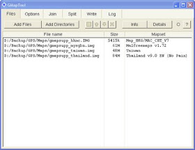
Under the Files section of GMapTool, select the maps you want to combine by clicking on Add Files (to select one file at one time) or Add Directories (to select all *.img files in the directory). Note that you can always remove any file in the listing by selecting it and press the Delete button of your keyboard.


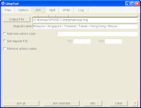
When you are done with the mapset selection, continue to the Join section.


Specify the Output File, and key-in the Mapset name of your file to be created. This mapset name will be displayed under each of the map name when you list your maps in Map Info function of your Garmin GPS.

Click the Join all button, and the combined mapset will be created. You can then copy the new mapset file to your Garmin's internal storage or SD card.

Note that if any of the maps in your mapset file is locked by vendor, you still need the 25 bytes unlock key stored in a *.unl file in the same folder and with the same name as the mapset file where the locked map is stored in. To unlock 2 maps inside the mapset file, put both the keys inside the *.unl file one after another, without space (the file size will be 50 bytes then).

To get rid of the hassle, you might want to use another tool called Garmin Unlocker to permanently unlock the maps before combining them with GMapTool.

You might probably be interested to also read about:

Friday, August 28, 2009

Inside of the Garmin Nuvi 255w GPS exposed

No, I have not opened up my Garmin Nuvi 255w GPS to see what is inside, but others did.

You can click here to go and see some interesting photos of the internal electronic parts of the Nuvi 255w device after the cover is opened up.

And here is a professional technical write-up on the internal of Garmin Nuvi 205, which is a smaller and more compact unit with 320x240 display in the Garmin 2x5 family.

Click here to see the interesting photos of the internal of Garmin Nuvi 205 (with label description).

From these information, we can guess that our Garmin Nuvi 255w GPS is having:

Tuesday, August 25, 2009

Garmin Hotfix technology powered by Rx Networks GPStream SAGPS chipset

Newer Garmin Nuvi GPS including the 205, 205w, 255, 255w, 265T, 265WT, 275T, 500, 550, 750, 760, 770, 780, 755t, 765t, 775t, 785t, 850, 880, 5000, etc. have a new selling point of Hotfix technology.

Garmin Hotfix enable the GPS to be super fast within seconds in locating the satellites during startup. In fact, my Garmin Nuvi 255w can even work as if staying connected to satellites for a few minutes, when it started up indoor in the middle of my house.

This is made possible by using predictive calculations of satellite positions, which enables the behaviour of GPS satellites to be modelled based on broadcast ephemeris readings for accurate prediction of satellite positions up to a few days ahead. A single broadcast ephemeris reading allows the accurate prediction of satellite orbits which are developed and refined every time new broadcast ephemeris is obtained.

Some people are guessing that the Hotfix feature is based on SiRF InstantFix inside the newer version of SiRFstarIII chipset. However, we've just found out that Nuvi 255w is using STMicro Cartesio application processor instead, so it is not SiRF InstantFix which plays the magic.

In fact, the Garmin Hotfix technology is powered by Rx Networks GPStream SAGPS chipset. The GPStream Self Assisted GPS (SAGPS) is a derivative of GPStream Predicted GPS (PGPS) technology. GPStream PGPS is a 3rd generation Assisted GPS (AGPS) solution addressing the limitations of 1st and 2nd generation products, which is made available to some handphone devices with AGPS feature.

Click here to read more about Rx Networks GPStream SAGPS technology.

For those who are interested to know where I got the information about Garmin Nuvi 255w is using STMicro Cartesio application processor and Rx Networks GPStream SAGPS technology, it is mentioned in Page 10 of September 2008 edition (Volume 11 Issue 9) of Telecom Trends newsletter.

Monday, August 24, 2009

Cartesio chipset used in Garmin Nuvi 255w GPS

I've been wondering what kind of GPS chipset is inside my Garmin Nuvi 255w GPS. Some say it is the famous SiRFstarIII, some say it is the Taiwanese MTK chipset, but I find out that it is actually the STMicro Cartesio.

In fact, all the current Garmin Nuvi 2x5 series of GPS are using this Cartesio automotive-grade infotainment application processor with embeded GPS receiver. It features the System-on-Chip (SoC) technology which combines the host CPU and a high-performance 32-channel GPS correlator, and also a large set of peripherals and interfaces.

Here are some of the technical information about the STMicro Cartesio (code name STA2062):
  • High performance ARM926 333-MHz CPU
  • High performance 32-channel GPS correlator
  • Bus/DDR frequency is 166 MHz
  • 32 KB embedded ROM for boot
  • 2 banks of 64 KB embedded SRAM
  • 0.5 KB embedded SRAM for back-up
  • 4 GB total linear address space
  • Operating temperature range from -40 to 85 °C
Click here for more information on the STMicro Cartesio.

My GPS usage experience shows that this STMicro Cartesio is performing pretty good.

Switch the Garmin Nuvi GPS to Simulator Mode and vice-versa

The Garmin Nuvi GPS will automatically prompt you an option to switch to Simulator Mode when it is not able to contact with the satellites. Simulator Mode allows you to use the functions of the GPS, such as planning for a route to destination, even when you are indoor and cannot get satellites signal. Simulator Mode is very useful when you want to demo the GPS functions to others.

You can manually set the GPS into Simulator Mode, even when the GPS is able to get ssatellites signal, by going to Tools > Settings > System > GPS Mode and select "GPS Off". The GPS signal strength indicator on the top-left corner of the screen will have a red cross when you are in Simulator Mode.


From the Simulator Mode, you can switch your GPS back to "Normal" mode and start acquiring satellites signal by going to the same setting place.

View the complete route to destination in Garmin Nuvi GPS

After you have set your destination in Garmin Nuvi GPS and before you tap on the "Go" button, you can actually view the complete route that your GPS has calculated by tapping on the "Route Info" area.

You might need some passion to wait for the calculation to complete, and it might take some seconds before the "Route Info" area slide out and appear on the screen.


A map will appear after you tap on the "Route Info" area. The route to your destination will be shown as a magenta line in the map.


You can tap on the [+] button to enlarge the map, drag the map will your finger to scroll the display area.

If you are already in the Map Screen showing your route to destination, you can also reach the above map showing the complete route by first tapping on the green bar which display the current road name on top of the screen, then tap on the "Show Map" button below the next screen.

If you don't like this calculated route, try to adjust your Avoidances setting in Tools > Settings > Navigation > Avoidances. Then try again.

If you still don't like the calculated route, you can also inform the GPS to make a detour.

How to change the current route in Garmin Nuvi GPS

Garmin Nuvi GPS has a "detour" function, which allows you to change to a different route from the current, to go to the same destination you are heading to.

When you are in the map screen, tap on the Menu button will bring you back to the main screen. If you are on the way to a destination, you will be able to see the "Detour" button below "Where to?". Just tap on it to make a detour.

Saturday, August 22, 2009

BookFest @ Malaysia 2009 in KLCC now

With the theme of "Reading is Inspiring" (阅读创思维), today (22 August 2009) is the first day of the 4th BookFest @ Malaysia (第四届海外华文书市) organized by Popular Book Co, co-organized by Sin Chew Media Corp and MCA Life Long Learning Secretariat.

It is deemed as one of the largest Chinese and English book exposition held in Southeast Asia, featuring publishers from China, Hong Kong, Taiwan, United Kingdom, Singapore and Malaysia.

This year, it is held in Kuala Lumpur Convention Centre as follow:
Date: 22-31 August 2009
Time: 10am - 10pm
Venue: Hall 1-5, KL Convention Centre
Exhibition area: 100,000 square feet
No. of booths: 500+
Entrance fee: RM2 for general public. Free admission for students 18 years and below and senior citizen who are 60 years and above.

I have just came back from this event. Despite the current fear of influenza A(H1N1), the crowd is still there.

The Chinese book area starts from Hall 5 and the English book area starts from Hall 1. The stage event is in the middle (near to Hall 3). There are also lots of booths displaying and selling stationeries, music CDs, video DVDs, multimedia titles, computer accesories, paper shredders, laminators, digital dictionaries, GPS, digital camera, camcorder, etc.

Speakers to be on stage including Nicholas Teo (张栋梁), Amber Chia (谢丽萍), Angel Wong Chui Ling (王翠玲), Patsie Cheong (张莉婵) and many more.

Wednesday, August 19, 2009

Accessing system debug info of Garmin Nuvi 255w

I've just discovered another hidden feature in my Garmin Nuvi 255w GPS, which is the system debug info screen. Here is the trick to get there.

In the map screen, touch the left capsule beside the Menu button to open the Trip Computer screen. You'll be able to see a speedometer on the screen. Press and hold your finger at the center of the speedometer for at least 6 seconds, and you'll be able to see the system debug info screen.


All the information shown in the few pages of the system debug info screen are very technical. Interestingly, you'll be able to find out that the Garmin Nuvi GPS navigator can automatically defrag its storage from time to time.


You can just press the Quit button to quit the system debug info screen.

Hard reset Garmin Nuvi 255w GPS to factory default

In the Quick Start Manual of Garmin Nuvi 255w GPS, it stated that you can reset the unit by pressing the RESET button at its bottom. However, the RESET button is not found in my Nuvi 255w.

Additional information in the Owner's Manual stated that if RESET button is not found, slide the POWER key and hold it for more than 8 seconds will do the same, but I found out doing so will go to the touch screen calibration utility instead.

Another section in the Owner's Manual under the title "Clearing User Data" stated that holding your finger on the lower-right corner of the screen while turning on the unit and keeping the finger pressed until a message appear, that will allow you to delete all user-entered information.

I tried it and a message window pops up asking about "Do you really want to erase all user data?". There are 2 buttons to select, Yes or No. If you want to try this, make sure you've backup the data in your unit before answering to Yes.

So is the Clearing User Data be the same function as performing a hard reset to the unit? I don't have the confirmed answer yet.

Friday, August 14, 2009

Customize the speech of Garmin or TomTom GPS (both TTS and non-TTS)

Boring about hearing "recalculating" from your Garmin GPS and wanted to listen to something else, such as "oops, you don't follow my way"?

TurboCCC has come out with some interesting software tools for Garmin GPS users to easily customize the speech of their unit by hacking/modifying into the *.VPM voice files inside the /Garmin/Voice folder.

The tool to be used on Text-to-speech (TTS) voice file is called TTSVoiceEditor, and it can do the following:

  • Change speech phrases like "recalculating" to something more enjoyable
  • Control voice volume (level)
  • Change voice rate (speed)
  • Change the voice screen name
  • Import/Export speech phrases from/to text files

Click here for more information and download of TTSVoiceEditor.

And to deal with non-TTS file, another tool called NonTTSVoiceEditor is used. It can:

  • Split a Garmin VPM file into a serie of WAV files
  • Split a TomTom CHK file into a serie of OGG files (Vorbis audio files)
  • Preview and play WAV voice samples and phrases
  • Merge them back into a VPM file

Click here for more information and download of NonTTSVoiceEditor.

Beside that, there is also a tool for you to replace some sound effects in Garmin GPS, such as during the picture click, the camera in sight dong-dong, the speed alert, etc. This tool will hack into the /Garmin/GUPDATE.GCD file in the GPS. It is called GUpdateMod.

Click here for more information and download of GUpdateMod.

TurboCCC has also produced some other tools such as the Extra_POI_Editor, TTS_Speech_Doctor, TomTom TTS, etc.

Wednesday, August 12, 2009

Microsoft prohibited from selling MS Word due to patent infringement!

A CNET news today reported about Judge Leonard Davis of the U.S. District Court for the Eastern District of Texas has issued a permanent injunction that "prohibits Microsoft from selling or importing to the United States any Microsoft Word products that have the capability of opening .XML, .DOCX or DOCM files (XML files) containing custom XML.

In March 2007, the Toronto based plantiff, i4i sued Microsoft alleging that Microsoft voilated its 1998 patent (No. 5,787,449) for a document system that eliminated the need for manually embedded formatting codes.

In May 2009, a federal jury in Tyler, Texas, ruled that the custom XML tagging features of MS Word 2003 and MS Word 2007 infringed on i4i's patent and ordered Microsoft to pay $200 million in the case.

In Tuesday's ruling, Microsoft was also ordered to pay an additional $40 million for willful infringement, as well as $37 million in prejudgment interest. The order requires Microsoft to comply with the injunction within 60 days and forbids Microsoft from testing, demonstrating, or marketing Word products containing the contested XML feature.

I'm sure this will not be the end of the story. Let's see how Microsoft react on this.

Source: CNET News - Judge orders Microsoft to stop selling Word by Steven Musil.

Saturday, August 8, 2009

How to set destination using Panoramio photo in Garmin GPS

Do you know that you can interestingly set your destination in Garmin GPS by selecting a photo of the location you want to go? The feature is called Garmin Photo Navigation.


You need to download the Panoramio photos from the Photo Navigation section in the Garmin Connect website at http://connect.garmin.com/photos.

I'll show you how to do that, step-by-step.

Ensure that your Garmin GPS device is connected to your computer with a USB cable, and that you have already installed Garmin Communicator Plugin Software in your computer.

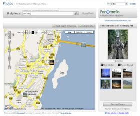
Get your browser to go to the Garmin Connect Photo Navigation website.

You need to sign in your Garmin customer account if you haven't done so.

Look for Panoramio photos in your desired location by searching with the "Find photos" search. For example, key-in "Penang" to find photos around Penang.

You can zoom-in the Google Map to your convenient size. There might be more than one page of photos which you can switch between the pages with the "Photos" pagination bar on top of the Google Map.

Select the photos by click on them one by one. Click on the [+] button of the enlarged (selected) photos to put them in your selection list.

When you have done, click the "Send to Device" button to download the Panoramio photos to your GPS device.


Remember to also contribute some photos taken by you to Panoramio.com website.

The photos will be stored in the /Garmin/JPEG folder of your Garmin GPS device.

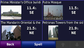
Now, switch your attention to your Garmin GPS device and go to "Where to? > Favorites > Panoramio Photos".

Select a photo and click the "Map" or "Go!" button. Have fun!

How to capture screenshots of Garmin Nuvi GPS

One of my reader asked about how I captured the screenshots of my Garmin Nuvi GPS. In fact, it is a built-in feature.

To enable screenshot capturing, go to Tools > Settings > Display > Screen Shot and change the setting from the default "Disabled" to "Enabled". You will then see a camera icon appear on the top right corner of the screen. Tap on it anytime and the screenshot of the current screen will be captured in a *.BMP graphics file stored in the /Garmin/scrn folder of your GPS navigator.

Just connect your GPS to your computer using a USB cable, and your GPS internal memory will be mounted as a remote drive for you to access its content. You can then copy over the screenshot files stored in the /Garmin/scrn folder.

Attended the AGM of ICAP and listened to Tan Teng Boo's talk

I attended the 5th Annual General Meeting (AGM) of iCapital.biz Bhd (ICAP, 5108) today 8-8-2009. This closed-end fund is very considerate to its shareholders to conduct the AGM on Saturday, so that working people don't have to take leave to attend it.

The AGM was held in Mandarin Oriental Hotel at the heart of Kuala Lumpur (KLCC). Hundreds of shareholders (and proxies) have attended the meeting, filling up all the seats. The major attraction is a special talk by Mr. Tan Teng Boo, the fund manager of ICAP, right after the AGM.


Mr. Tan has shared about the latest portfolio of ICAP and his rationale to choose those counters. He is bullish on Parkson's China and Vietnam business, Astro's joint-venture in India, etc. He is even bullish in F&N after their contract with Coca-Cola expired. He shared about his view on the reason of recent worldwide economy crisis, what is the real cause (the Lehman Panic), how will be the recovery process in his opinion, and where are we now. All the points are well supported by facts and figures, which shows that he has done numerous studies on his talking points.

Mr. Tan also enlighten us about the value investing way of stock buy/sell strategy. In the Q&A session, he answered some of the questions from his investors on why ICAP not applying the "cut lost" or "cut gain" strategy normally used by chartists, and how ICAP not trading based on price movement or market timing but based on fundamental studies. He also shared his viewpoint on the Malaysia market, US market, China market, India market, SEA markets, etc. It was really a fruitful discussion between ICAP's investors and the fund manager.

Inside the eco-friendly reuseable door-gift bag are:

  • 2 most recent issue of iCapital.biz printed version newsletters (30-7-09 & 6-8-09).
  • A nice feminine-shaped pen.
  • 30% discount + free gift subscription form to iCapital.biz newsletter.

This 5th AGM of ICAP started at around 10am and ended by around 1.30pm. Mr Tan has taken about 2 hours for his informative talk, and a lot of investors have participated in the Q&A session.

I'm looking forward to attend the next AGM next year.

Click here to read another article about ICAP 5th AGM by another blogger.

Friday, August 7, 2009

Website to download free firmware and map updates for Garmin GPS navigator

Garmin provides free firmware update and maps update (if applicable) for their series of GPS navigator products.

Before you can perform the updates, here are the prerequisites:

After you login the Garmin customer support website and registered your GPS product, just go to the myDashboard tab and you'll find the section to update your firmware (software) as well as your maps that eligible for update with Garmin.


If your Garmin GPS is a localized Sing/Mal or India product, you can also download the update file from their Singapore customer support website which does not need to create any user account nor install the Garmin Communicator Plugin Software.

Step by step instruction will be provided on how to perform the update.

Alternatively, you can also perform software update by using the Garmin WebUpdater application. This application will help you perform the update easily in a step-by-step manner.


As normally advised, always backup all the important content in the flash memory of your GPS before you perform any update to the software or to the maps. A copy-and-paste from the GPS flash memory to a folder in your computer will do.

Thursday, August 6, 2009

Adding multiple maps in Garmin Nuvi 255w GPS

Theoretically, the Garmin Nuvi GPS navigator can be loaded with hundreds of map. The limit is on the maximum file size (about 2GB per file) and available storage memory.

The maps are stored in specific mapset files with *.img extension in the flash memory of the GPS unit. Each mapset file contains one or many maps in it. Beside that, the Garmin GPS navigator can also recognise and load up one additional mapset file from SD card residing in the "Garmin" folder and named as "gmapsupp.img".

Here are the mapset files supported by Garmin Nuvi 255w GPS navigator:
  • gmapbmap.img - the default base map
  • gmapprom.img - the primary mapset
  • gmapprom1.img - the secondary mapset
  • gmapoem.img - the OEM mapset that cannot be unselect by user (if it exist)
  • gmapsupp.img - the supplemental mapset which you can have one in the GPS flash memory and another one in the attached SD card.
Therefore, the Garmin Nuvi 255w GPS supports up to 6 mapset files, including 1 in SD card. Normally new maps installed by the user will be stored in gmapsupp.img.

You will lost all the maps in the previous mapset file if it is overwritten by a new file with same filename. If you want to keep the existing maps, ensure that you store the mapset file with an unused filename (from the 5 filenames above). Alternatively, you can make use of special tools to merge new maps into existing mapset file.

You can view the name of your base map in Tools > Settings > System > About > Basemap.

You can view the name of maps in the other mapset files in Tools > Settings > Map > Map Info. There, you can tell the GPS to load the map by checking on its name, or not to use the map by unchecking it.

In case there are 2 or more non-overlaping maps available for the same location, the map with the highest priority number (defined in the map itself) will be used by the GPS.

Note that certain map which are locked by vendor need a 25 bytes unlock key stored in a *.unl file in the same folder and with the same name as the mapset file where the locked map is stored in.

You might probably also interested to read:

Accessing the built-in Diagnostic Utility in Garmin Nuvi 255w GPS

Just discovered that there is a "hidden" built-in Diagnostic Utility in Garmin Nuvi 255w GPS navigator.

You can access it by tapping on the battery icon on the upper right corner of the screen and hold for more than 5 seconds until the Diagnostic Utility come up. Here is how it looks like:


This built-in Diagnostic Utility allows you to see detail technical information of the GPS navigator and the attached SD card (if any). You can also use it to perform some test on its memory, voice, display, and other functions.

Wednesday, August 5, 2009

My Garmin Nuvi 255W GPS navigator

I have just bought a Garmin Nuvi 255W portable GPS navigator in PIKOM PC Fair II 2009 at the price of RM849. It is a SING/MAL unit which comes with new features such as Junction View, Lane Assist, etc.

Here are some useful information for those who are also interested in this model of Garmin GPS navigator. Note that this unit is a localized version sold in Malaysia and Singapore only.


In the packaging box, there is:

  • The Garmin Nuvi 255W GPS navigator
  • Vehicle suction cup mount
  • Vehicle power cable
  • Dashboard disk
  • Quick start manual

Free gifts from vendor as PC Fair promotion:

  • Screen protector film
  • Garmin leather case
  • USB cable


There is no complete user manual come with the box, but the full user manual in PDF format can be downloaded from Garmin website.

The following maps are preloaded in the GPS navigator:
  • City Navigator Singapore/Malaysia NT v4.02
  • Malsingmaps Malaysia/Singapore/Brunei NT 2009.5
  • Thailand v9.0 EN (No Pain)

And I managed to install Malfreemaps v1.68 together with MFM SRTM Topo v1.02 available in http://www.malfreemaps.com/.


How do we know this is a SING/MAL unit which supports Junction View and Lane Assist?

  • Underneath the packaging box, the SKU number should be 010-00718-69 and barcode labeled with "nuvi 255W, SING/MAL".
  • In Tools > Settings > System > About screen, you should be able to see "SgMy Software Ver. 2.70".
  • You can set the unit into simulation mode and travel through some major junctions around KL urban area to see how it works. Ask the vendor to demo to you on the unit that you're going to buy.


There are many ways to navigate and set destination in the Garmin Nuvi 255W GPS. You can set the location by address, telephone number, various points of interest (POI, such as those shown below), intersections, coordinates, etc.


This unit supports the "speak street name" feature, but you have to select a speaking voice that support for Text-to-speech (TTS) in order for this feature to function. There is one mandarin speaker voice which support TTS, but she will just spell out the name like "J-A-L-A-N ..." instead of pronouncing it as "Jalan ...". Anyhow, the American and British TTS are working well with Malaysian road names.


Tuesday, August 4, 2009

GPS gadget buying guide

The Global Positioning System (GPS) gadget has become one of the attraction in the recent PIKOM PC Fair II 2009 held in KL Convention Centre, and I have just purchased one.

Although most (if not all) of us can survive without using a GPS on travelling, GPS is no doubt a fun and handy device to guide our journey, because:
  • It can help us to discover new paths that we never tried before.
  • It can determine for us which is the fastest / shortest / fuel saving / most comfortable / ... path to destination.
  • It can guide us to avoid certain paths, such as toll roads, traffic jam area, etc.
  • It is extremely useful when travelling outstation or overseas, as we no longer need the traditional paper map, compass, ask people-on-street for direction, etc. (provided the GPS has the map of the place)
  • It can alert us on danger road condition ahead, traffic limit, speed traps, point of attractions, etc.
  • It can help us to easily locate and go to the nearest petrol station, restaurant, hospital, police station, etc. (especially during emergency)
  • With it, we can join the interesting "geocaching" activity as our new hobby.
  • And many more interesting things...
Here are my considerations when selecting the GPS:

1. Price - Yes, my first consideration is the pricing, as GPS is considered a "want" instead of a "need". I would not consider any GPS which cost above RM1,000. There are GPS gadgets that come with additional features such as bluetooth, multimedia (can play MP3, movie, etc.) which are beyond its basic function and make the unit cost higher, which I think we don't really need to pay for the price for those fancy things. However, we should think about getting the best of the price we are paying for, instead of just simply choosing a cheap unit which probably might disappoint us later.

2. Availability of maps - Without the maps, GPS is considered useless. Therefore, the GPS I choose must have many maps around the globe available for download or purchase when needed. Those maps must be actively developed and maintained. It would be even better if there are maps available for free.

3. Clear display and voice - We rely on the GPS screen and voice to guide our way. Therefore, the screen display should be clear, sharp and non-glare during daytime and night time. The voice also need to be clear and loud enough. Availability of voice in native languages such as Cantonese, Hokkien, Hakka, etc. is a plus.

4. Handy size - I personally like the 4.3" widescreen make of GPS. The screen is big enough for us to see clearly, while this size is still portable and can be put in our pocket. The 3.5" units seems to be small, and the 5" units are a little bit bulky.

5. Accuracy - The GPS must be very accurate in positioning the location. At the same time, the map must also be accurate in plotting the location. The variation between the actual location and GPS shown location must not exceed 5 meters.

6. Respond speed - The GPS must be fast in signaling with the satellites, perform fast recalculation on changed route, inform us early on turning and POIs ahead, etc. This is very much depends on the GPS chipset and the processor speed in the unit. It would be very annoying if your GPS respond is slow.

7. Stable signaling - The GPS must be fast as well as stable in contacting and receiving signals from the satellites. Conditions of lost contact with satellites should not occur unless the unit is in-house or heavily covered from the sky. Recovery after the obstacle is cleared (such as coming out from a long tunnel) must be quick.

8. Navigation and searching features - The GPS should be easy to use, with handful of good navigation and searching features.

9. Memory - The larger the memory, more maps and records can be kept. The internal memory should be at least 2GB, with support of external memory such as SD card.

10. Cool features - Cool features such as 3-D map, junction views, lane assist, pronounce road names, etc. are most welcomed as long as the price of the unit is still within budget.

11. Battery life and ease of charging - The battery should be able to last for at least 4 hours. It would be nice if the GPS can be charged from computer using USB cable, as the USB cable is one of the cheapest charging cable (cost around RM15 only) compared with car charger, household AC charger, etc.

12. Self-service - I would like to be able to upgrade the GPS firmware, upload maps, manipulate maps, etc. with software or tools that is easy to use and made available for the users.

13. Warranty & service - The vendor must be known to provide good warranty and service support, including maps updating services in the future.

14. Free gifts - Free maps (and subsequence updating service of the maps), pocket casing, screen protector film, etc. are nice to negotiate for.

15. Extra features - The least considerations are those extra features such as picture viewer, photo viewer, multimedia functions, calculator, currency converter, etc.

Based on the above, I've chosen my Garmin Nuvi 255w (SING/MAL unit) which cost me RM849 in the PIKOM PC Fair II 2009.